
AN amber weather warning for wind affecting the South West has been issued by the Met Office as the latest storm, Storm Henk, arrives.
Storm Henk will bring a spell of very strong winds to parts of the UK leading to potential disruption to travel and infrastructure.
An area of low pressure crossing southern regions of the UK, now named Storm Henk, will bring an area of very strong winds through Tuesday.
► What can you expect?


- Flooding of a few homes and businesses is possible
- Spray and flooding on roads probably making journey times longer
- Bus and train services probably affected with journey times taking longer
Initially the strongest gusts will be focused around southwest England and south Wales during the late morning and early afternoon. Here gusts of up to 80mph are possible in exposed coastal locations.
As the low pressure moves north-eastwards the strongest wind gusts also move eastwards across the UK with many parts of southern England, the south Midlands and East Anglia experiencing 50-60mph gusts through the afternoon and evening. Inland gusts could reach up to 60-70mph in one or two places for a time.
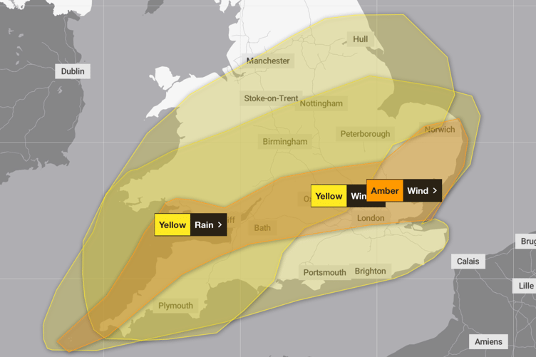
An Amber severe weather warning for wind has been issued for these regions from 10:00 this morning [January 2] through to 20:00 this evening.
A wider Yellow severe weather warning for wind covers the whole of southern England and Wales.
A Yellow warning for rain covers a wide area of England and Wales as further rain moves in through the day.
Rainfall totals from 17:00 on Monday to 21:00 Tuesday are likely to reach 15-30mm with 35-50mm in a few places.
Comments
This article has no comments yet. Be the first to leave a comment.